The geological disaster monitoring needs continuous online data collection for a long time, because of collecting data of the terrain is relatively complex, some traditional monitoring methods cannot meet the needs of geological disaster monitoring. Therefore, this paper discusses the use of LoRa wireless network technology, embedded disaster monitoring system to realize distributed monitoring data management and low power consumption, effectively improve the geological disaster the reliability and real-time of the monitoring system.
Key words: geologic disaster, LoRa, telemetry terminal
1. System Overview
Geological disasters come from natural and man-made disasters, and the four types of geological disasters are landslide, collapse, debris flow and land subsidence. Due to the installation of monitoring equipment in the field environment, meteorological conditions and geographical environment is relatively poor, the coverage of the communication network is not ideal. If the LoRa wireless network technology is introduced in the collection layer and data transmission layer of the traditional geological disaster monitoring system, can greatly improve the real-time and reliability of the monitoring of geological disasters, ensure all day long 24h real-time monitoring, timely and accurate to provide an effective basis for disaster warning.
2. System design

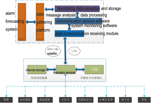
2.1 The system adopts the layered and distributed structure. The first layer is the data acquisition of the telemetry station, collect the monitoring data of each monitoring station. The second layer is the remote wireless transmission network. Through GPRS/SMS/satellite /LoRa and other means of communication, the platform can send the command to the monitoring station, at any time to call the station to measure the historical data, the monitoring station can be immediately reported to the timing data or alarm data. The third layer is data aggregation platform, through the network connection monitoring center station to realize the data sharing, make it constitute an early warning system of management automation.
2.2 The system adopts advanced technologies, such as information telemetry, software engineering, network, modern communication, artificial intelligence and so on. Fast acquisition and storage of geological disaster monitoring points rainfall, mud, soil moisture, sound, infrasound real-time data and monitoring equipment working voltage and temperature data.
2.3 Front end data acquisition sensor and data transmission telemetry terminal are integrated LoRa communication module. It adapts to the high and low temperature environment. It has low power consumption, high stability, easy to install and so on, also completely meet the harsh field working conditions.
2.4 Monitoring system supports GPRS/SMS/3G/satellite and other means of communication to send up to a remote center. And also can meet through the LoRa wireless sensor network, sensor nodes, terminal nodes and the central node to communicate with each others.
3. System Application Integration
3.1 Industry supervision
3.1.1 Integrated design
The data acquisition terminal adopts modular design, which has the characteristics of low power consumption and low cost. The built-in LoRa communication module, can carry out centralized management and control of sensor nodes, and the sensor data collected for processing and storage.
3.1.2 Network self-healing
Without manual intervention, the network nodes can perceive the existence of other nodes, and determine the connection relationship, which constitute a structured network. When the node position changes or there is a failure, the network can self repair, and do the corresponding adjustment of the network topology, to ensure that the system is stable and normal work.
3.1.3 High Compatibility
The center node has coordinated function, in addition to the completion of sending and receiving terminal node over request and data management, network terminal node is responsible for the maintenance, network structure, network self-organization, and connect to the GPRS network, data transmission and command between complete and monitoring center management, completely meet the requirements of data transmission of geological disaster monitoring system.
3.2 Reliable Operation and Maintenance
3.2.1 Transmission security
The system set up the disaster forecast center, in order to ensure the reliability of data transmission and improve the data flow rate, in the forecast centers of the main channel of GPRS+LoRa, to avoid the single channel faulty cause communication terminal.
3.2.2 Interference immunity
In order to ensure that the monitoring and early warning and forecasting center can get the data of the monitoring station at any time, and read any time data or monitoring station work status and other information. After the data arrives at the monitoring center server, the first is data received by the communication program, and the communication program is responsible for the dis-assembly and the decoding of the data packet. This process reduces the bit error rate and improves the data integrity. Then the monitoring data is synthesized and stored in the database and stored in the log file.
3.2.3 Low power consumption design
The system uses a timed wake-up mode to manage all levels of nodes. When the data need to be collected by the monitoring center issued a command to the center node, the center node again wakes up each terminal node and starts data acquisition and transmission. Terminal nodes will be collected rainfall, displacement, tilt, pressure and other data through the fusion, and then transmitted to the central node.
3.2.4 Low cost of operation and maintenance
Compared to the traditional GPRS data transmission, LoRa data transfer does not require additional operating costs, can significantly reduce the cost of operation and maintenance of the late project.
4. Discussion
With the further development of wireless sensor network market, in this paper, the LoRa wireless network sensor technology is introduced into the geological disaster monitoring system. The number of terminal nodes can be arbitrarily increased or deleted in the wireless network, increase the flexibility of geological hazard monitoring, widening of the geological disaster monitoring area, reduce the power consumption of the whole system, save system cost and improve the real-time performance and reliability of the geological disaster monitoring system. Therefore, it can be popularized in the monitoring of geological disasters.


